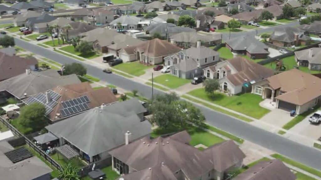
Modern property valuation methods have evolved significantly, with aerial property tax valuation playing a key role. Today, Texas appraisal districts rely on a range of data tools and technologies including aerial photos, geographic information systems (GIS), and advanced software to assess properties more quickly and efficiently. While these innovations improve coverage and consistency, they also raise concerns about accuracy and context in aerial property tax valuation.
At TexasPVP, we believe that understanding how your local appraisal district values your property through methods like aerial property tax valuation is key to challenging inaccurate assessments and protecting your investment.
Why Appraisal Districts Use Aerial Imagery
Appraisal districts are tasked with valuing thousands of properties each year. To manage this scale, many districts now use aerial photography and satellite imagery to:
- Identify structural changes like new additions or garages
- Monitor lot conditions and land usage
- Detect unauthorized improvements or demolitions
- Verify square footage and property outlines
These photos are often updated annually and cross-referenced with permit data, ownership records, and GIS overlays to build a comprehensive view of each parcel. Consequently, aerial property tax valuation becomes crucial for maintaining fair property assessments.
How This Affects Your Property Tax Valuation
When aerial or satellite images show visible changes to your property, the appraisal district may use that data to:
- Increase your valuation based on perceived improvements
- Correct lot boundaries and sizes
- Compare your property to neighboring parcels for uniformity
This means your property’s assessed value may rise even if you haven’t formally reported any changes.
What Data Tools Are Used in Appraisal
Appraisal districts now combine aerial photography with other data-driven technologies:
- GIS mapping for analyzing land use and zoning
- CAMA systems (Computer-Assisted Mass Appraisal) to automate assessments based on property characteristics
- Heat maps to spot value trends across regions
- Historical overlays to track changes over time
While helpful for mass efficiency, these systems may miss details like property condition, interior issues, or deferred maintenance. Therefore, it’s vital to understand how aerial property tax valuation utilizes these tools.
Risks and Limitations of Aerial Appraisal Methods
Though aerial data provides broad insight, it doesn’t tell the full story:
- It can’t assess interior condition or damage
- It may misclassify temporary structures as permanent improvements
- Tree cover or shadows can obscure critical details
- Timing of images may misrepresent current property state
Because of these limitations, relying solely on aerial data may result in overvaluations which is why it’s important to challenge inaccuracies with ground-level evidence.
How to Protect Yourself as a Property Owner
If your valuation increases unexpectedly, check for:
- New aerial photos of your property
- Errors in lot boundaries or building footprints
- Additions or features that may be misidentified
You can request this information from your county appraisal district or consult a property tax consultant like TexasPVP.
We help clients cross-examine aerial data with real-world evidence such as:
- Photos of current property condition
- Permits or lack of them
- Comparable properties with similar structures
How TexasPVP Helps You Respond
TexasPVP builds strong protest cases by:
- Reviewing appraisal district aerial data for errors
- Comparing your property to nearby comps
- Gathering physical evidence that contradicts assumptions from photos
- Representing you in both informal and formal hearings
We understand how automated systems can overlook key details. Our team steps in to correct them before they affect your tax bill.
Final Word: Don’t Let a Photo Decide Your Tax Bill
Technology is a tool, not the final word. If your property is being appraised unfairly based on aerial photos or mass data, you have the right to respond. With the right documentation and a trusted partner, you can ensure your valuation reflects reality — not just what’s seen from above in the aerial property tax valuation process.
Need help understanding your appraisal data? Contact TexasPVP today and let us build your case from the ground up.